9Apps services for free Android apps. 20,000+ users downloaded Mobile Topographer latest version on 9Apps for free every week! Once you've used it, you'll be attracted. This hot app was released on 2019-05-25. Here are some guides of this app:
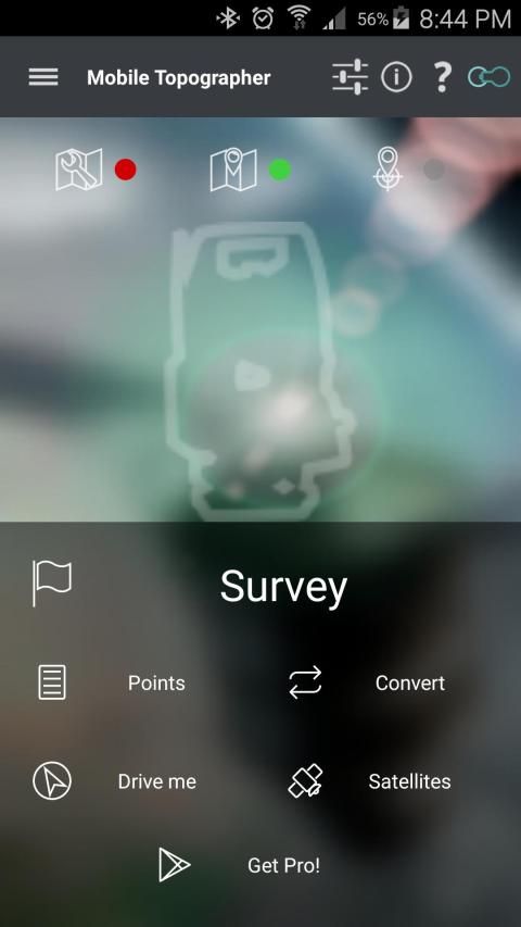
Your mobile Topographer!
The leading tool for the professional surveyor or anyone who wants to mark his property, offering the best accuracy and extensive functionality that no other app can!
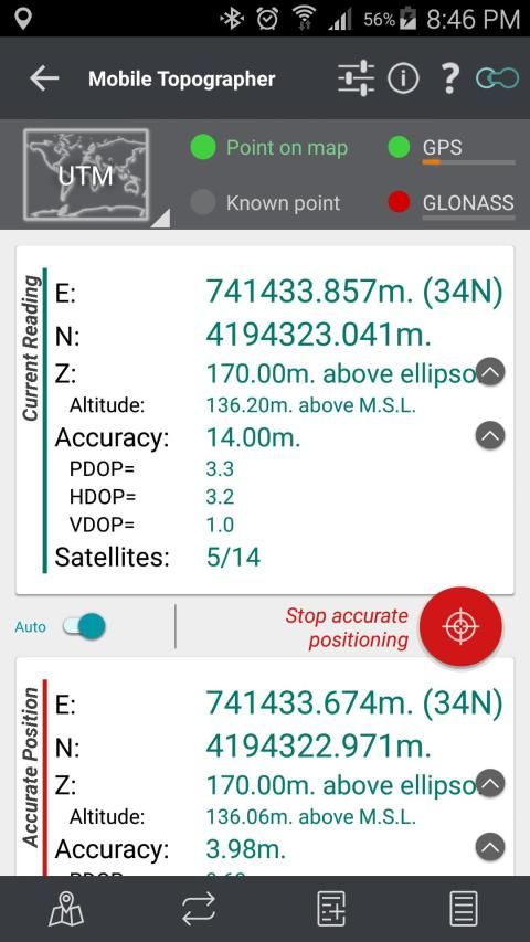
*** Increase GPS accuracy using:
- Weighted averaging (on every axis).
- Map calibration.
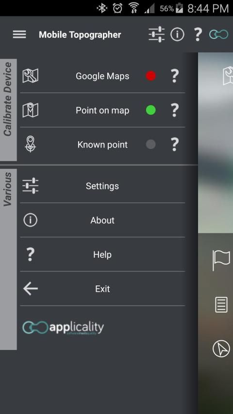
- Device calibration on map, or on a know point.
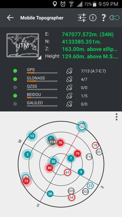
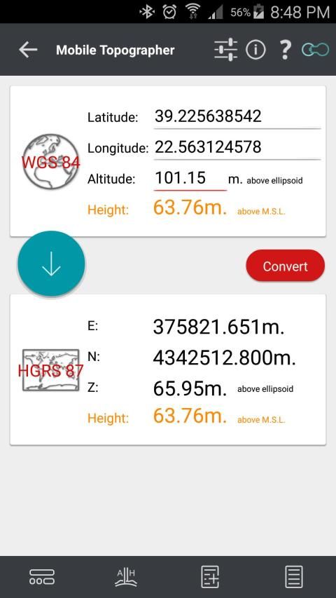
*** Display and convert GPS geodetic to Cartesian EN coordinates and back:
- UTM.
- Europe ETRS89/UTMZ28-38.
- Hellas HGRS 87 (EGSA 87).
- Hellas HGRS 87 - HEPOS.
- Hellas HTRS07/TM07.
- Iceland ISN93/Lambert 93.
- Morocco Merchich.
- SPCS83 (124 zones) USA.
- Romania S-42(58)/Stereo 70.
- Lebanon & Syria Deir ez Zor/Stereo.
- Croatia HTRS96/TM.
- Serbia SRB-ETRS89/UTM, SRB-MGI/Z7.
- Australia MGA94 (GDA94), AMG66 (AGD66) National, A.C.T., Northern Territory, NSW & Victoria, Tasmania,AMG84 (AGD84).
- Former FR of Yugoslavia MGI Balkans zones 5,6 & 7.
- Italy Monte Mario West Zone 1 Peninsular, West Zone 1 Sardinia, East Zone 2 Peninsular, East Zone 2 Sicily.
- Costa Rica CΜ05/CRTM05, Ocotepeque 1935 Costa Rica Norte & Ocotepeque 1935 Costa Rica Sur.
- Cyprus CGRS-93-LTM.
- Hungary HD72/EOV.
- Kosovo KosovaREF01.
- Latvia LKS92/TM.
- Lithuania LKS94/TM.
- Spain ED50/UTMZ29-30 NW, ED50/UTMZ29-31 ML & ED50/UTMZ31 BA.
- Uk's OSTN02/OSGM02.
- Turkey ED50/Gauss-Kruger 3° Z9-15, ITRF96 & ED50/UTMZ35-38.
- Luxembourg LUREF.
- Venezuala REGVEN/Z18-20.
- Sweden SWEREF99 TM.
- Argentina POSGAR 94 & POSGAR 2007.
- India Kalianpur 1975 ZI - ZIV.
- Algeria Nord Sahara 1959 / Z29-32.
- Armenia, Georgia, Azerbaijan, Estonia, Latvia, Lithuania, Russia - Kaliningrad and Kazakhstan Pulkovo 1942/ CS63 (A)Z1-4, (C)Z0-2, (K)Z2-4.
- Central and South America SIRGAS 2000.
- Nigeria and Cameroon Minna 1996 & 2008 MTM West, Mid, East Belts & UTM Z31-33.
- Bangladesh Gulshan 303/TM.
- France RGF93/CC42-50.
- Canada CSRS
- Egypt 1907 Blue, Red, Purple, Extended Purple belts.
- Portugal ETRS89/PTM06.
- Netherlands Amersfoort/RD new.
- Qatar QND95.
- Colombia MAGNA-SIRGAS Far West, West, Bogota, Central East, East zones.
- Mexico ITRF 2008/LCC.
- Madagascar Tananariva (Paris)/Laborde & Tananariva/UTM Z38-39S .
- Tunisia Carthage (Paris)/Mining Grid, Carthage/Nord, Carthage/Sud, Carthage/TM 11 NE, Carthage/UTM zone 32N.
- Liechtenstein CH1903/LV03C-G.
- Switzerland CH1903/LV03 (old), CH1903+/LV95 (new).
- Brazil SAD69/UTM Z18-25 & SAD69(96)/UTM Z18-25
- Spain Canary Islands REGCAN95/LAEA & REGCAN95/LCC & REGCAN95/UTM Z27-28
*** Auto stop for accurate positioning.
*** Examine the satellites above you in a sky view.
*** Signal strength and number of satellites indication for each GNSS constellation individually.
*** Multiple units support:
- Meters,
- International feet,
- US survey feet.
***Height calculation:
- Ellipsoidal height.
- EGM96 orthometric height calculation.
*** Convert from geodetic to Cartesian coordinates and back:
- Support for device measured points, or
- Manually input of geodetic or Cartesian coords.
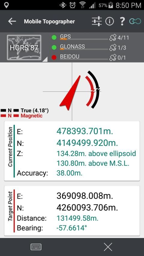
*** Drive me:
- Key in coordinates of the target point in either geodetic or Cartesian coordinates, or select a point from the list and follow the pointer.
- Compass indicating both magnetic and true North.
***
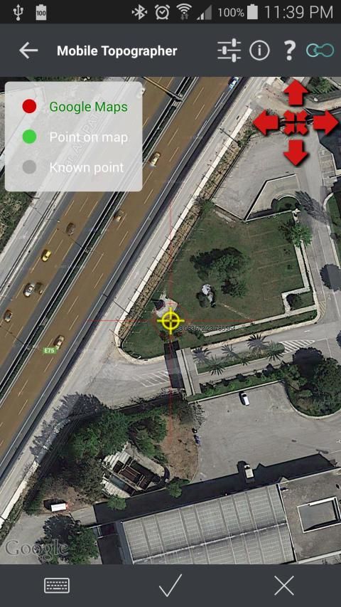
Project on Map:
- Project individual points on any map application.
- Project list of points, and the defined polygon, on embedded maps.
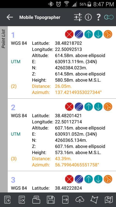
*** Save multiple point lists, to use them later.
*** Calculate area.
*** Export point lists το:
- .txt (text file)
- .csv (point file - comma separated)
- .kml (google earth file)
- .gpx (Gps Exchange format)
- .dxf (drawing file)
*** Send file via e-mail, or upload it to cloud.
*** Complete help text support.
Help us improve Mobile Topographer by e-mailing your comments and suggestions.
TAGS: Survey Surveyor Property GPS GNSS GLONASS QZSS BEIDOU GALILEO
Topographer ponsel Anda!
Alat terkemuka untuk surveyor profesional atau siapa saja yang ingin menandai miliknya, menawarkan akurasi terbaik dan fungsionalitas yang luas yang tidak ada aplikasi lain bisa!
*** Meningkatkan akurasi GPS menggunakan:
- Weighted averaging (pada setiap sumbu).
- Peta kalibrasi.
- Perangkat kalibrasi di peta, atau pada titik tahu.
*** Tampilan dan mengkonversi GPS geodetik untuk Cartesian EN koordinat dan kembali:
- UTM.
- Eropa ETRS89 / UTMZ28-38.
- Hellas HGRS 87 (EGSA 87).
- Hellas HGRS 87 - HEPOS.
- Hellas HTRS07 / TM07.
- Islandia ISN93 / Lambert 93.
- Maroko Merchich.
- SPCS83 (124 zona) USA.
- Rumania S-42 (58) / Stereo 70.
- Lebanon & Suriah Deir ez Zor / Stereo.
- Kroasia HTRS96 / TM.
- Serbia SRB-ETRS89 / UTM, BPRS-MGI / Z7.
- Australia MGA94 (GDA94), AMG66 (AGD66) Nasional, A.C.T., Northern Territory, NSW & Victoria, Tasmania, AMG84 (AGD84).
- Mantan FR dari zona Yugoslavia MGI Balkan 5,6 & 7.
- Italia Monte Mario Barat Zona 1 Peninsular, Zona Barat 1 Sardinia, Zona Timur 2 Peninsular, Zona Timur 2 Sisilia.
- Kosta Rika CΜ05 / CRTM05, Ocotepeque 1935 Kosta Rika Norte & Ocotepeque 1935 Costa Rica Sur.
- Siprus CGRS-93-LTM.
- Hongaria HD72 / EOV.
- Kosovo KosovaREF01.
- Latvia LKS92 / TM.
- Lithuania LKS94 / TM.
- Spanyol ED50 / UTMZ29-30 NW, ED50 / UTMZ29-31 ML & ED50 / UTMZ31 BA.
- Uk ini OSTN02 / OSGM02.
- Turki ED50 / Gauss-Kruger 3 ° Z9-15, ITRF96 & ED50 / UTMZ35-38.
- Luksemburg LUREF.
- Venezuala REGVEN / Z18-20.
- Swedia SWEREF99 TM.
- Argentina POSGAR 94 & POSGAR 2007.
- India Kalianpur 1975 ZI - Ziv.
- Aljazair Nord Sahara 1959 / Z29-32.
- Armenia, Georgia, Azerbaijan, Estonia, Latvia, Lithuania, Rusia - Kaliningrad dan Kazakhstan Pulkovo 1942 / CS63 (A) Z1-4, (C) Z0-2, (K) Z2-4.
- Amerika Tengah dan Selatan SIRGAS 2000.
- Nigeria dan Kamerun Minna 1996 & 2008 MTM Barat, Mid, Sabuk East & UTM Z31-33.
- Bangladesh Gulshan 303 / TM.
- Prancis RGF93 / CC42-50.
- Kanada CSRS
- Mesir 1907 Biru, Merah, Ungu, Extended sabuk Purple.
- Portugal ETRS89 / PTM06.
- Belanda Amersfoort / RD baru.
- Qatar QND95.
- Kolombia MAGNA-SIRGAS Far West, West, Bogota, East Central, zona Timur.
- Mexico ITRF 2008 / LCC.
- Madagaskar Tananariva (Paris) / Laborde & Tananariva / UTM Z38-39S.
- Tunisia Carthage (Paris) / Pertambangan Grid, Carthage / Nord, Carthage / Sud, Carthage / TM 11 NE, Carthage / UTM zona 32N.
- Liechtenstein CH1903 / LV03C-G.
- Swiss CH1903 / LV03 (tua), CH1903 + / LV95 (baru).
- Brasil SAD69 / UTM Z18-25 & SAD69 (96) / UTM Z18-25
- Spanyol Canary Islands REGCAN95 / IAEA & REGCAN95 / LCC & REGCAN95 / UTM Z27-28
*** Auto berhenti untuk posisi yang akurat.
*** Periksa satelit di atas Anda dalam tampilan langit.
*** Kekuatan sinyal dan jumlah satelit indikasi untuk setiap konstelasi GNSS individual.
*** Beberapa unit mendukung:
- Meter,
- Kaki International,
- Kaki survei US.
*** Perhitungan Tinggi:
- Ellipsoid tinggi.
- EGM96 ortometrik perhitungan tinggi.
*** Konversi dari geodesi ke koordinat Cartesian dan kembali:
- Dukungan untuk perangkat diukur poin, atau
- Manual input coords geodesi atau Cartesian.
*** Berkendara saya:
- Key di koordinat titik sasaran di koordinat baik geodetik atau Cartesian, atau pilih titik dari daftar dan ikuti pointer.
- Kompas menunjukkan kedua magnet dan benar Utara.
***
Proyek di Peta:
- Proyek poin individu pada setiap aplikasi peta.
- Daftar Proyek poin, dan poligon didefinisikan, pada peta tertanam.
*** Simpan beberapa daftar titik, untuk menggunakannya nanti.
*** Hitung daerah.
*** Daftar titik Ekspor το:
- .txt (File teks)
- .csv (Titik berkas - dipisahkan koma)
- .kml (File bumi google)
- .gpx (Gps Efek format)
- .dxf (File gambar)
*** Kirim file melalui e-mail, atau meng-upload ke awan.
*** Dukungan bantuan teks lengkap.
Bantu kami meningkatkan Ponsel topographer melalui e-mail komentar dan saran.
TAGS: Survey Surveyor GPS Properti GNSS GLONASS QZSS Beidou GALILEO
v.9.3.2 - Small bug fix prevented some devices with high DOP values to collect readings.


9Apps 4.9